
airboats protecting the habitat

posted: Sunday, 15 June 2014
by: Lori Potter
ELM CREEK — Flashes of white feathers dove into Platte River shallows near the Kearney Canal diversion as interior least terns fished for breakfast on a sunny, calm Monday morning.
After catching a fish, the tiny birds darted toward sandbars and the Blue Hole State Wildlife Management Area east of the Elm Creek bridge. “This is always a pretty well-fished location for the least terns because the water drops off,” said airboat pilot and wildlife biologist Dave Zorn, as he used binoculars to count five birds.
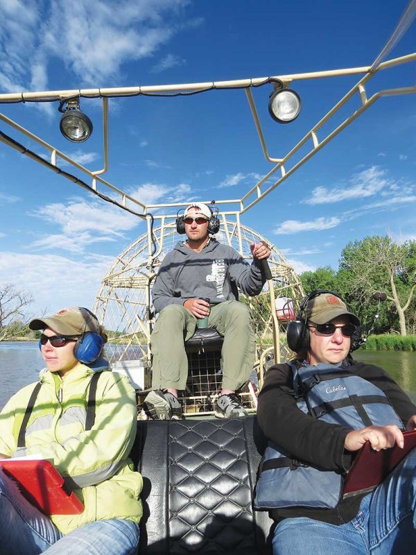
Wildlife biologists, from left, Staci Cahis, Dave Zorn and Colleen Rothe-Groleau watch for least terns, piping plovers and nests on Platte River sandbars east of the Elm Creek June 2 during a bimonthly Platte River Recovery Implementation Program bird survey by airboat from Lexington to Chapman. Cahis and Zorn work for Headwaters Corporation in Kearney, which is the program’s executive director’s office, and Rothe-Groleau of Weeping Water is with the U.S. Geological Survey.
Another wildlife biologist, Staci Cahis, used a global positioning system device while recording on a form the birds’ exact location and activities. Least terns, piping plovers and whooping cranes are the three threatened or endangered bird species on the federal Endangered Species List that use the Central Platte River. Whooping cranes may stop on river sandbars during spring and fall migration seasons, while the two shorebirds nest on sandy beaches in the valley.
Zorn and Cahis work for Headwaters Corporation in Kearney, which provides the executive director, Jerry Kenny, and staff for the three-state Platte River Recovery Implementation Program. The program’s mission is to study and protect water and land habitats in and along the Central Platte that are used by the three bird species.
Tracking trends
The process includes airboat surveys of the river from Lexington to Chapman, twice a month from May through August, to observe tern and plover behaviors, and to see if they have nests on river sandbars.
Headwaters Wildlife Biologist David Baasch said, “We document birds foraging in the river or nesting on the sandbars to help get a picture of how many birds are on the river sandbars.” He oversees the survey teams, and works on river and land habitat restoration projects. At the request of the Nebraska Game and Parks Commission, the three-member survey teams — the third participant is assigned by the U.S. Geological Survey and was Colleen Rothe-Groleau of Weeping Water on June 2 — also check a dozen bald eagle nests.
Most least tern and piping plover nests are on active and closed sandpits along the river that are owned by the Platte Program or Nebraska Public Power District. Those sites are surveyed twice a week, Baasch said, and the river sandbars also would be checked that often if nests are found. Survey data goes into a PRRIP database to help biologists track trends as the program creates habitat. “The belief is that as you build habitat, you get more birds,” Baasch said. Another interest is understanding preferred nesting site conditions. “If they choose this (a feature),” he said, “then we should build more of that type of thing.”
Restoring sandbars
Program officials continue to hire contractors to build “high and dry” river sandbars with bulldozers to reflect the birds’ natural nesting areas before the Platte River was changed by diversions and other developments. “Keeping vegetation off of these islands has been a challenge,” Baasch said, explaining that there often isn’t enough water flowing to scour unwanted plants from the higher sandbars.
Several such islands covering 25 to 30 acres were built just downstream of the Kearney Canal diversion, which is about 1½ miles east of the Elm Creek bridge. Baasch said terns and plovers have been observed using those islands in past years, although not building nests. When the river went dry during late summer in many recent years, the sandbar islands turned into “just lumps in the river.”
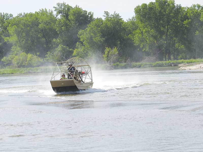
A three-member team of wildlife biologists prepares to survey the Platte River near the Elm Creek bridge early on June 2. It usually takes three days to do an airboat survey from Lexington to Chapman looking for least terns and piping plovers.
The PRRIP surveys from Lexington to Chapman via airboat, which cover all Central Platte channels at least 75 to 100 feet wide, were done once a month from 2001-2009. “It just didn’t feel like that was enough,” said Baasch, who started working for Headwaters in 2009. Piping plovers nest in early May and fledge chicks in early July. Least terns lay eggs in late May or early June and fledge chicks in early to mid July. Baasch said a second survey each month was added in case birds nested the day after the first one, and to note more regularly the conditions affecting river flows and sandbar conditions. It takes a team three long days or two very long days to complete a survey.
Adaptive management
The process fits a primary PRRIP principle called adaptive management. It says that when a plan or project is initiated to improve habitat for target species, studies must be done to see if the goals actually are being met. Baasch said that while dozer work continues to create river nesting sites and control sandbar vegetation, it has been determined that adding sediment to the river is not producing similar desired results and won’t be done anymore. To ensure favorable nesting conditions at the sandpits, where mining tends to be deeper and with smaller spoil piles than in the past, he said program officials require mining companies to use a shallower method or leave a larger sand area.
Baasch said PRRIP records show that plover numbers observed in the river and at sandpits grew from 30 to 40 when the program began in 2007-2008 to 65 to 70 today. Similarly, least terns numbers have increased from an estimated 60 to 80 in 2007 to 120 to 130 now. “It’s just been kind of a gradual increase,” he said. Baasch added that it will take a few more years to know if the increase is due to providing more preferred nesting habitat or reflects a bird population cycle.
Airboat surveys
Getting an accurate bird count is the responsibility of surveyors who must have keen eyes to identify least terns and piping plovers that are similar in size and coloration to other shorebirds using the river. “You kinda get used to the different features they have,” Zorn said, including the wing beat. “A lot of times we take second looks at the sandpipers and killdeers, especially the small killdeers that look more like plovers.”
Another identification aid can be individualized color-coded bands on the legs of least terns and piping plovers captured and banded by USGS teams. However, Zorn said it can be difficult to see the bands on the shorter-legged terns. When asked if he’s the Mark Twain of airboat captains, who now knows every sandbar and log in the river from Lexington to Chapman, Zorn smiled and said he does have a map in his head.
He said his two passengers are mostly looking for least terns, piping plovers and any nests, and his main job is to put the airboat into position so they don’t miss anything. Zorn acknowledged that while it’s easy to see birds at their favorite fishing spot near the Kearney diversion, it’s much more difficult to identify nesting sites that are “pretty camouflaged” on the river sandbars.

